As mentioned in the section Creating custom polygons, Tableau does natively provide polygons for several shape files.
Exercise: polygons for Texas
Exercise: steps
In this exercise, we will use a .shp file to show the population of Texas:
- Google the Texas City Limits Shape file and open the Texas Department of Transportation page.
- On the right side, use the download dropdown and download the shape file.
- In your download directory you should find multiple files:
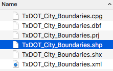
- In the workbook associated with this chapter, navigate to the Texas_Cities worksheet and select Data > New Data Source > Text File.
- Navigate to the download directory and select the .shp file (which is also selected in the latest screenshot).
- Double-click...