Creating a feature dataset
A feature dataset is a container for feature classes that have the same spatial reference, Coordinate Reference System (CRS), spatial domain, resolution, and tolerance. In the case of importing features with the same CRS, the feature dataset will accept only the features that have their coordinates between the minimum and maximum values defined for the x, y, z and m values of spatial domain extent. A feature dataset cannot contain other feature datasets or non-spatial tables.
Note
For more details about the feature dataset, please refer to the online ArcGIS help (10.2) by navigating to Geodata | Data types | Feature datasets from http://resources.arcgis.com/en/help/main/10.2.
Getting ready
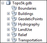
You will create seven feature datasets: Buildings, GeodeticPoints, Hydrography, LandUse, Relief, Transportation, and Boundaries. In your file geodatabase, Topo5k.gdb, all feature datasets will have the same CRS.
How to do it...
Follow these steps to create feature datasets in a file geodatabase using the ArcCatalog context menu:
- Start ArcCatalog. In Catalog Tree, go to
<drive>:\PacktPublishing\Data\MyGeodatabase, and select Topo5k.gdb. - Right-click on Topo5k.gdb, and navigate to New | Feature Dataset for the Name type
Buildings. Click on Next. Navigate to Projected Coordinate Systems | National Grids | Europe | Pulkovo 1942 Adj 1958 Stereo 1970. Select the active yellow star Add To Favorites to add the selected projected coordinate system to the Favorites section. You will use this projected coordinate system later in this book. - Click on Next. Navigate to Vertical Coordinate Systems | Europe | Constanta. Click on Next. Accept the XY, Z, and M tolerance values. Keep checked the option Accept default resolution and domain extent (recommended).
- If you want to see the default values for resolution and domain extent, uncheck them and click on Next. Examine the default values, and click on the Finish button.
- If you want to examine the default values for domain, resolution, and tolerance, right-click on
Buildingsfeature datasets and navigate to the Properties | Domain, Resolution and Tolerance tabs. - Repeat the previous steps to create the following feature datasets:
GeodeticPoints,Hydrography,LandUse,Relief, andTransportation, as shown in the following screenshot:
- To inspect the results, return to the Feature Dataset Properties dialog.
How it works...
After you have created a feature dataset, ArcCatalog allows you to change only the XY and Z coordinate system. If you take the decision to change the XY coordinate system for a feature dataset, you should know that you cannot modify the values for domain, resolution and tolerance. If you still need to change the CRS for a feature dataset, it will be more proper to create the feature dataset from the beginning. In conclusion, when you are thinking about a feature dataset, think twice and act once.
There's more...
In ArcCatalog, you can use Copy and Paste from the context menu in the file geodatabase to duplicate the first feature dataset. In the Data Transfer window, you can change the name of the feature dataset by typing in the Target Name section. In this case, the newly resulted feature dataset will have the same coordinate reference system as the source feature dataset.
See also
- For more information about CRS, please refer to Chapter 3, Working with CRS


