Search icon CANCEL
Arrow left icon
Explore Products
Best Sellers
New Releases
Books
Videos
Audiobooks
Learning Hub
Conferences
Free Learning
Arrow right icon
Arrow up icon
GO TO TOP
Practical GIS

You're reading from   Practical GIS Learn novice to advanced topics such as QGIS, Spatial data analysis, and more

Arrow left icon
Product type Paperback
Published in Jun 2017
Publisher Packt
ISBN-13 9781787123328
Length 428 pages
Edition 1st Edition
Languages
Tools
Arrow right icon
Author (1):
Arrow left icon
G√°bor Farkas G√°bor Farkas
Author Profile Icon G√°bor Farkas
G√°bor Farkas
Arrow right icon
View More author details
Toc

Table of Contents (15) Chapters Close

Preface 1. Setting Up Your Environment FREE CHAPTER 2. Accessing GIS Data With QGIS 3. Using Vector Data Effectively 4. Creating Digital Maps 5. Exporting Your Data 6. Feeding a PostGIS Database 7. A PostGIS Overview 8. Spatial Analysis in QGIS 9. Spatial Analysis on Steroids - Using PostGIS 10. A Typical GIS Problem 11. Showcasing Your Data 12. Styling Your Data in GeoServer 13. Creating a Web Map Appendix

Setting up the tools

Most of the software used in this book is platform-dependent; therefore, they have different ways of getting installed on different operating systems. I assume you have enough experience with your current OS to install software, and thus, we will focus on the possible product-related pitfalls in a given OS. We will cover the three most popular operating systems--Linux, Windows, and macOS. If you don't need the database or the web stack, you can skip the installation of the related software and jump through the examples using them.

Make sure you read the OS-related instructions before installing the software if you do not have enough experience with them.

The list of the software stack used in this book can be found in the following thematically grouped table:

Some of these packages are changeable; you can try them out if you have enough experience or have some time for tinkering. For example, you can use nginx instead of Apache, or you can use the WAR (Web Archive) version of GeoServer with your Java servlet instead of the platform independent binary. You can also use pgAdmin 4 and any subversion of GRASS 6 or GRASS 7 (or even both of them).

Installing on Linux

Installing the packages on Linux distributions is pretty straightforward. The dependencies are installed with the packages, when there are any. We only have to watch out for three things prior to installing the packages. First of all, the package name of the Apache web server can vary between different distributions. On distros using RPM packages (for example--Fedora, CentOS, and openSUSE), it is called httpd, while on the ones using DEB packages (for example--Debian and Ubuntu), it is called apache2. On Arch Linux, it is simply called apache.

While Arch Linux is far from the best distribution for using GIS, you can get most of the packages from AUR (Arch User Repository).

The second consideration is related to distributions which do not update their packages frequently, like Debian. GeoServer has a hard dependency of a specific JRE (Java Runtime Environment). We must make sure we have it installed and configured as the default. We will walk through the Debian JRE installation process as it is the most popular Linux distribution with late official package updates. Debian Jessie, the latest stable release of the OS when writing these lines, is packed with OpenJDK 7, while GeoServer 2.11 requires JRE 8:

You can check the JRE version of the latest GeoServer version uses at http://docs.geoserver.org/latest/en/user/installation/index.html. You can check the JRE version installed on your OS with the terminal command update-alternatives --list java.
  1. To install OpenJDK 8, we have to enable the Backports repository according to the official Debian guide at https://wiki.debian.org/Backports.
  2. If the repository is added, we can reload the packages and install the package openjdk-8-jre.
  3. The next step is to make this JRE the default one. We can do this by opening a terminal and typing the following command:
      update-alternatives --config java
  1. The next step is self-explanatory; we have to choose the new default environment by typing its ID and pressing enter.
Make sure to disable the Backports repository by commenting it out in /etc/apt/sources.list, or by checking out its checkbox in Synaptic after installing the required packages. It can boycott further updates in some cases.

The last consideration before installing the packages is related to the actual version of QGIS. Most of the distributions offer the latest version in a decent time after release; however, some of them like Debian do not. For those distros, we can use QGIS's repository following the official guide at http://www.qgis.org/en/site/forusers/alldownloads.html.

After all things are set, we can proceed and install the required packages. The order should not matter. If done, let's take a look at GeoServer, which doesn't offer Linux packages to install. It offers two methods for Linux: a WAR for already installed Java servlets (such as Apache Tomcat), and a self-containing platform independent binary. We will use the latter as it's easier to set up:

  1. Download GeoServer's platform independent binary from http://geoserver.org/release/stable/.
If there is absolutely no way to install OpenJDK 8 on your computer, you can use GeoServer 2.8, which depends on JRE 7. You can download it from http://geoserver.org/release/2.8.5/.
  1. Extract the downloaded archive. It can be anywhere as long as we have a write permission to the destination.
  2. Start GeoServer with its startup script. To do this, we navigate into the extracted archive from a terminal and run startup.sh in its bin folder with the following command:
      cd <geoserver's folder>/bin
./startup.sh
  1. Optionally, we can detach GeoServer from the shell used by the terminal with the startup command nohup ./startup.sh > /dev/null &. This way, we can close the terminal. If we would like to shut down GeoServer manually, we can do so by running its shutdown.sh script.
By default, the shell closes every subprocess it started before terminating itself. By using nohup, we override this behavior for the GeoServer process, and by using & at the end of the command, we fork the process. This way, we regain control over the shell. The >/dev/null part prevents nohup from logging GeoServer's verbose startup messages.


Installing on Windows

Installing the required software on Windows only requires a few installers as most of the packages are bundled into the OSGeo4W installer.

  1. First of all, we have to download the 32-bit installer from https://trac.osgeo.org/osgeo4w/ as this is the only architecture where an OSGeo version of Apache is bundled.
  2. Opening the installer, we can choose between different setups. For our cause, we should choose Advanced Install. When we reach the Select Packages section, we must choose the following packages as a minimum:
  • Desktop--grass, qgis
  • Web--apache, qgis-server
  1. The next page tells us we don't have to bother with dependencies as the installer selected them for us automatically.
  2. The last step can be quite troublesome as there isn't a general solution; we have to configure Apache and QGIS Server if they don't want to collaborate (opening http://localhost/qgis/qgis_mapserv.fcgi.exe returns an Internal Server Error or it simply cannot be reached). For a good start, take a look at the official tutorial at http://hub.qgis.org/projects/quantum-gis/wiki/QGIS_Server_Tutorial.

Don't worry if you end up with no solutions, we will concentrate on GeoServer, which runs perfectly on Windows. Just make sure Apache is installed and working (i.e. http://localhost returns a blank page or the OSGeo4W default page), as we will need it later.

If you would like to install the 64-bit version of Apache separately, you can find suggestions on compiled 64-bit binaries at https://httpd.apache.org/docs/current/platform/windows.html.


  1. The next thing to consider is the PostgreSQL stack. We can download the installer from https://www.postgresql.org/download/windows/, where the EnterpriseDB edition comes with a very handy Stack Builder. After the installation of PostgreSQL, we can use it to install PostGIS. We can find PostGIS in the Spatial Extensions menu. The default installer comes with pgAdmin 4, while we will use pgAdmin 3 in this book. The two look and feel similar enough; however, if you would like to install the latter, you can download it from https://www.pgadmin.org/download/pgadmin-3-windows/.
The last thing to install is GeoServer, which is such an easy task that we won't discuss it. You can download the installer from http://geoserver.org/release/stable/. Make sure you have Java 8 (https://java.com/en/download/) before starting it!

Installing on macOS

Installing the software on macOS could be the most complicated of all (because of GRASS). However, thanks to William Kyngesburye, the compiled version of QGIS already contains a copy of GRASS along with other GIS software used by QGIS. In order to install QGIS, we have to download the disk image from http://www.kyngchaos.com/software/qgis.

If you need the GIS software on OS X 10.6 or older, take a look at Kyngesburye's archive at http://www.kyngchaos.com/software/archive. Before installing the software, make sure you read his hints and warnings related to the given image.

PostgreSQL and PostGIS are also available from the same site, you will see the link on the left sidebar. pgAdmin, on the other hand, is available from another source: https://www.pgadmin.org/download/pgadmin-4-macos/. Finally, the GeoServer macOS image can be downloaded from http://geoserver.org/release/stable/, while its dependency of Java 8 can be downloaded from https://www.java.com/en/download/.

If you would like to use pgAdmin 3 instead, or pgAdmin 4 is not supported by your OS, you can download pgAdmin 3 from https://www.pgadmin.org/download/pgadmin-3-macos/.

The only thing left is configuring the QGIS Server. As the OS X and macOS operating systems are shipped with an Apache web server, we don't have to install it. However, we have to make some configurations manually due to the lack of the FastCGI Apache module, on which QGIS Server relies. This configuration can be made based on the official guide at http://hub.qgis.org/projects/quantum-gis/wiki/QGIS_Server_Tutorial.

Getting familiar with the software

Congratulations! You're through the hardest part of this chapter. The following step is to make some initial configurations on the installed software to make them ready to use when we need them. First of all, let's open QGIS. At first glance, it has a lot of tools. However, most of them are very simple and self-explanatory. We can group the parts of the GUI as shown in the following image:

You can learn more about the individual GUI tools from the online QGIS manual at http://docs.qgis.org/2.14/en/docs/user_manual/introduction/qgis_gui.html. It is somewhat outdated; however, the GUI hasn't changed much since then (and presumably, it won't change anymore until QGIS 3.0).

We can describe the distinct parts of the QGIS GUI as follows:

  1. Main toolbar: We can manage our current workflow, pan the map, and make selections and queries from here. Additionally, new tools from plugins will end up somewhere here.
  2. Add layer: From this handy toolbar, we can add a lot of different spatial data with only a few clicks.
  3. Layer tree: We can manage our layers from here. We can select them, style them individually, and even apply filters on most of them.
  4. Map canvas: This is the main panel of QGIS where the visible layers will be drawn. We can pan and zoom our maps with our mouse from here.
  5. Status bar: These are the simple, yet powerful tools for customizing our view. We can zoom to specified scales, coordinates, and even rotate the map. We can also quickly change our projection, which we will discuss in more depth later.
  6. Processing toolbar: We can access most of the geoalgorithms bundled in QGIS, and even use other open source GIS clients when they are more fitting for the task.

The only thing we will do now without having any data to display, is customizing the GUI. Let's click on Settings and choose the Options menu. In the first tab called General, we can see some styles to choose from. Don't forget to restart QGIS every time you choose a new style.

Did you know that like much professional software, QGIS also has a night mode? You can toggle it from the UI Theme option in the General tab without restarting the software.

The next piece of software we look at is PostGIS via pgAdmin. If we open pgAdmin, the least we will see is an empty Server Groups item on the left panel. If this is the case, we have to define a new connection with the plug icon and fill out the form (Object | Create | Server in pgAdmin 4), as follows:


The Name can be anything we would like, it only acts as a named item in the list we can choose from. The Host, the Port, and the Username, on the other hand, have to be supplied properly. As we installed PostgreSQL locally, the host is 127.0.0.1, or simply localhost. As the default install comes with the default user postgres (we will refer to users as roles in the future due to the naming conventions of PostgreSQL), we should use that.

On Windows, you can give a password for postgres at install time and you can also define the port number. If you changed the default port number or supplied a password, you have to fill out those fields correctly. On other platforms, there is no password by default; however, the database server can only be accessed from the local machine.

Upon connecting to the server, we can see a single database called postgres. This is the default database of the freshly installed PostgreSQL. As the next step, we create another database by right-clicking on Databases and selecting New Database. The database can be named as per our liking (I'm naming it spatial). The owner of the database should be the default postgres role in our case. The only other parameter we should define is the default character encoding of the database:
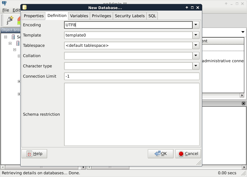
Choosing the template0 template is required as the default template's character encoding is a simple ASCII. You might be familiar with character encoding; however, refreshing our knowledge a little bit cannot hurt. In ASCII, every character is encoded on 8 bits, therefore, the number of characters which can be encoded is 28 = 256. Furthermore, in ASCII, only the first 7 bits (first 128 places) are reserved, the rest of them can be localized. The first 7 bits (in hexadecimal, 00-7F) can be visualized as in the following table. The italic values show control characters (https://en.wikipedia.org/wiki/C0_and_C1_control_codes#C0_.28ASCII_and_derivatives.29):

Character encoding is inherited by every table created in the database. As geographic data can have attributes with special local characters, it is strongly recommended to use a UTF-8 character encoding in spatial databases created for storing international data.

About the software licenses

Open source GIS software offer a very high degree of freedom. Their license types can differ; however, they are all permissive licenses. That means we can use, distribute, modify, and distribute the modified versions of the software. We can also use them in commercial settings and even sell the software if we can find someone willing to buy it (as long as we sell the software with the source code under the same license). The only restriction is for companies who would like to sell their software under a proprietary license using open source components. They simply cannot do that with most of the software, although some of the licenses permit this kind of use, too.

There is one very important thing to watch out for when we use open source software and data. If somebody contributes often years of work to the community, at least proper attribution can be expected. Most of the open source licenses obligate this right of the copyright holder; however, we must distinguish software from data. Most of the licenses of open source software require the adapted product to reproduce the same license agreement. That is, we don't have to attribute the used software in a work, but we must include the original license with the copyright holders' name when we create an application with them. Data, on the other hand, is required to be attributed when we use it in our work.

There are a few licenses which do not obligate us to give proper attribution. These licenses state that the creator of the content waives every copyright and gives the product to the public to use without any restrictions. Two of the most common licenses of this kind are the Unlicense, which is a software license, and the Creative Commons Public Domain, which is in the GIS world mostly used as a data license.

You have been reading a chapter from
Practical GIS
Published in: Jun 2017
Publisher: Packt
ISBN-13: 9781787123328
Register for a free Packt account to unlock a world of extra content!
A free Packt account unlocks extra newsletters, articles, discounted offers, and much more. Start advancing your knowledge today.
Unlock this book and the full library FREE for 7 days
Get unlimited access to 7000+ expert-authored eBooks and videos courses covering every tech area you can think of
Renews at €18.99/month. Cancel anytime