Raster data is not created like vector data. Quite often, raster data is created from other raster data, such as creating a slope raster from a topographic raster. Raster data can also be created from vector data, which can be done by gridding a series of coordinates/points. QGIS has the ability to perform all of these functions. We will further explore raster visualization in Chapter 4, Creating Great Maps, and processing rasters in Chapter 6, Extending QGIS with Python.
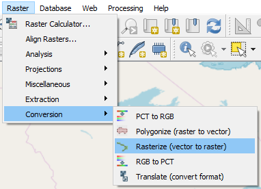
In this section, we will convert our Canada_Provinces.shp to a raster. In the menu, click Raster | Conversion | Rasterize (vector to raster), as shown in the following screenshot:

Vector to raster
In the following dialog box, enter these parameters:
- Input Layer: Canada_Provinces.
- Burn-in value: id.
- Output raster size units: Pixels.
- Width: 10 (this will create a raster with a width of 10 pixels...


