Search icon CANCEL
Subscription
0
Cart icon
Your Cart (0 item)
Close icon
You have no products in your basket yet
Save more on your purchases! discount-offer-chevron-icon
Savings automatically calculated. No voucher code required.
Arrow left icon
Explore Products
Best Sellers
New Releases
Books
Videos
Audiobooks
Learning Hub
Newsletter Hub
Free Learning
Arrow right icon
timer SALE ENDS IN
0 Days
:
00 Hours
:
00 Minutes
:
00 Seconds
Arrow up icon
GO TO TOP
R Data Visualization Cookbook

You're reading from   R Data Visualization Cookbook Over 80 recipes to analyze data and create stunning visualizations with R

Arrow left icon
Product type Paperback
Published in Jan 2015
Publisher
ISBN-13 9781783989508
Length 236 pages
Edition 1st Edition
Languages
Tools
Arrow right icon
Toc

Table of Contents (12) Chapters Close

Preface 1. A Simple Guide to R FREE CHAPTER 2. Basic and Interactive Plots 3. Heat Maps and Dendrograms 4. Maps 5. The Pie Chart and Its Alternatives 6. Adding the Third Dimension 7. Data in Higher Dimensions 8. Visualizing Continuous Data 9. Visualizing Text and XKCD-style Plots 10. Creating Applications in R Index

A guide to contour maps


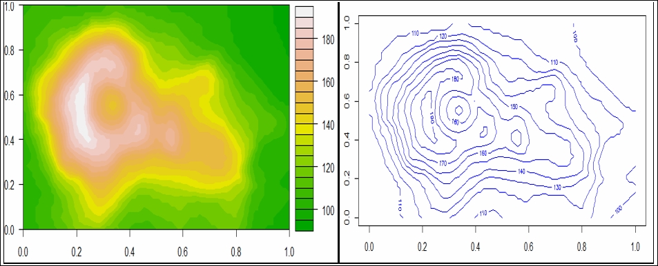
Contour maps have also been referred to as isometric maps or isopleth maps. Contour maps are used to display data related to temperature or topographic information. Most of the time, contour maps are used to display maps related to geology or mountains. The contour lines represent which sections of the mountains are steeper based on how close the contour lines are drawn from each other.
How to do it…

We can generate a contour map in R using the contour() function and also add a color to the contour using the filled.contour() function:

contour(volcano,  main = "Topographic map of a Volcano",col = "blue")
filled.contour(volcano, color.palette = terrain.colors,main = "Topographic map of a Volcano")

How it works…

In order to plot a simple contour plot, we will use the contour() function available with the basic R plotting functionality. The first argument passed in the contour() function is the data. The volcano dataset consists of topographic information on Auckland's Mauga...

lock icon The rest of the chapter is locked
Register for a free Packt account to unlock a world of extra content!
A free Packt account unlocks extra newsletters, articles, discounted offers, and much more. Start advancing your knowledge today.
Unlock this book and the full library FREE for 7 days
Get unlimited access to 7000+ expert-authored eBooks and videos courses covering every tech area you can think of
Renews at $19.99/month. Cancel anytime
Banner background image